Olifantshoek Tourism Information Bureau
Olifantshoek Business Directory
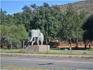 The name Olifantshoek is derived from the original Tswana name, “Ditlou”, which means “elephant” and was used due to the prevalence of these big animals in the area. If you are a traveler that loves hot summers and mild winters, and you are a “plattelandse mens”, then Olifantshoek is the ultimate vacation destination.
Olifantshoek is situated at the foot of Langberg, 130 kilometers east of Upington and 90 kilometers south west of Kuruman and on the main road between Gauteng and Namibia.
Before Olifantshoek came into existence, the land belonged to the Tswana’s; where tribes like the Thlaping and the Thlaro used to dwell. After a hundred years, in 1885, the Tswana rein came to an end when the area was annexed and became part of British Betsjoeanaland. In 1895 British Betsjoeanaland became part of the Cape Colony.
“The Jewel of the Kalahari” as the village is known was named after the tusks of an elephant which was used as payment for the farm on which the original town was build. Olifantshoek is also referred to as the “Gateway to the White and Roaring Sands.”
The first brick buildings that was build in 1906 was a police cell and a magistrate office, next to the office there was a large tent that served as Olifantshoek first court. The first resident to build a house, in 1909, was a policeman of the Cape Mounted Police, Sgt. Hubert Warren.
Back in those days, police patrolling was done on camel back. These camels were obtained from a camel breeding station at Witdraai in the Kalahari, but his camel back patrolling came to an end in 1946.
The most important challenges for the development of Olifantshoek were the distance from service centers and bad communication lines with other towns. These challenges were mainly caused by poor local roads, but in 1975, the road between Kuruman and Upington, traveling over Olifantshoek was completed; which made Olifantshoek much less isolated.
The old car registration number rewarded to Olifantshoek – CEW – was often referred to as an abbreviation for “corrugations everywhere” – with reference to the condition of the local roads before 1975. Since the year 2000, Olifantshoek forms part of the Tsantsebane Municipality with its head office in Postmasburg.
|
Municipality |
Surrounding Towns |
|||||
| 1. Kathu 2. Postmasburg 3. Upington 4. Kuruman |
5. Deben 6. Van Zylsrus 7. 8. |
|||||
| Telephone | : 000 000 0000 | |||||
| Mobile | : 000 000 0000 | |||||
| Fax | : 000 000 0000 | |||||
|
Emergency Numbers |
||||||
| Ambulance 000 000 0000 |
Police 000 000 0000 |
Fire Brigade 000 000 0000 |
Hospital 000 000 0000 |
Traffic 000 000 0000 |
Airport 000 000 0000 |
|

Olifantshoek Accommodation & Leisure Activities
Click on the establishment’s name for more details.
BED & BREAKFAST: |
GUEST HOUSE: |
LODGE: |
HOTEL: |
| No Listing | No Listing | No Listing | No Listing |
GUEST FARM: |
SELF CATERING: |
CHALET: |
OVERNIGHT ROOM: |
| No Listing | No Listing | No Listing | No Listing |
HOLIDAY RESORT: |
CARAVAN PARK: |
CAMPING SITE: |
NATURE RESERVE: |
| No Listing | No Listing | No Listing | No Listing |
Olifantshoek Tourism Attractions:
Click on the attraction’s name for more details.
| No Listing | No Listing |
Olifantshoek Education:
Click on the institution’s name for more details.
DAY CARE FACILITY |
PRE SCHOOL |
PRIMARY SCHOOL |
HIGH SCHOOL |
| No Listing | No Listing | No Listing | No Listing |
COLLEGE / UNIVERSITY |
INSTITUTION |
PRIVATE SCHOOL |
SPECIAL SCHOOL |
| No Listing | No Listing | No Listing | No Listing |
Olifantshoek Business Directory:
Click on the business name for more details.
RESTAURANT: |
FAST FOOD: |
BUTCHERY: |
FRUIT & VEGETABLE: |
| No Listing | No Listing | No Listing | No Listing |
CONSTRUCTION: |
PROPERTY: |
MAINTENANCE: |
SECURITY: |
| No Listing | No Listing | No Listing | No Listing |
![]()